
It always puzzled me how many of the place names in our area came to be. I assume there is an agency in the MNR that is responsible for assigning place names but they sometimes have no relationship to the people who have lived here. Some township names were assigned to MPPs or to others I have no explanation for. This was originally going to be an appendix in my book but was dropped to save space.
Algoma – created in 1859, most of Ontario
Comes form Ojibwa..ah-ga-wu – meaning other side of the water
lake and lands of the Algoms, an Algonkian Indian tribe
Name of district came from Ojibwa name for Lake Superior
Alton – part of town in Caledon
Antrim – named after county in Ireland
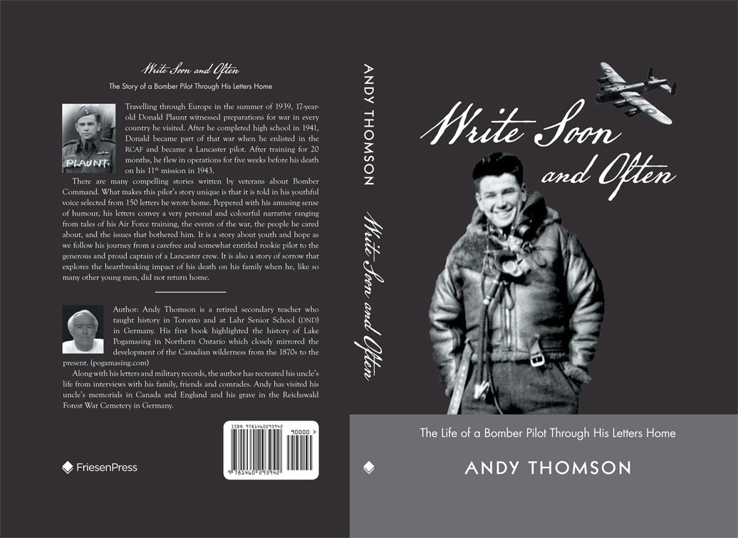
Benny – divisional engineer with the CPR, 50 families living there in the early 1920’s when it was the site for the Hope Lumber Company. W. B. Plaunt purchased the band mill and assets of the company after it closed in 1930. A road was built between Benny and Cartier in 1934, but it became a ghost town in the ‘30’s as there was no work. Now it is home to a few families, mostly aboriginals.
Biscotasi – name of township
Biscotasing – Ojibway for “a body of water with long arms”
Frontier town in CPR construction; 1886 CPR moved operation to Chapleau
Bisco became fur trade post in l888 after the Pogamasing post was closed that same year. Booth and Shannon built a saw mill in 1908, fire nearly wiped out whole village in 1913, lumber mill closed in 1927.
Cartier – subdivided by PLO Proudfoot in 1885, named after Georges-Etienne Cartier, HWY 144 replaced road built in 1930’s. CPR yard
Chapleau – federal politician from Quebec, Natives called it Nemegosee
Craig – township named for John Craig, MPP for Wellington East from 1894-1911 (south end of Kennedy and Bluewater)
Dennie named for H. C. Dennie, a candidate for the Ontario Land Surveyors exams in 1872. Surveyed in 1888 (DeGurse) and 1911(Code)
Espanola –named “little Spain” “The area at one time was occupied by Spanish Indians, presumably from Spanish Central America.” Dam built on Spanish River at Webbwood Falls, town named in 1902 by Spanish River Pulp and Paper Company, mill completed in 1905, purchased by Abitibi in 1928, closed during the depression, POW camp to 1943 when KVP took it over –sent the POW’s to bush camps. Some say it was named after the Spanish speaking Indians who came up from areas controlled by Spanish, however, we now know it was after the grandfather of Louis Espagnol (the first person in the area who was called by this name) who was a Spanish-speaking trader from the American southwest.
Fluorite – a mineral that may have been found in the area and given the name of a CPR siding. One map indicated the name was ‘Flybite’ possibly because they found more pests than flurospar
Forks – once called Spanish Forks, refers to the place in the Spanish River where the east and west branch meet, an original siding and stop on CPR created is 1884
Gilden – combination of Gilbert and Dennie
Gilbert – named after Marwood Gilbert, a local patentee (land owner)
La Fleche – named in 1945 after the General Leo Richer La Fleche, soldier, diplomat, co-founder of the Canadian Legion (contains north ends of Pog and Little Pog)
McGinnis Island – named after American family who purchased it in 1958.
Moncrieff – township near Benny named for George Moncrieff, M. P from Lambton East, 1887-96
Monro Siding – the original name for the CPR stop now called Sheahan. It was named for J. W. Monro, a lumberman who operated in the Pogamasing area from 1897 to 1902 and who installed the siding(footprint of this siding is still visible).
Morse – named for John Morse, patentee of mining lands north of Thunder Bay, northern boundary surveyed in 1888 (Proudfoot) and township created in 1911 (Code)
Pogamasing – Most of us grew up on Pog believing that Pogamasing meant ‘lake of many narrows’. In my research I have found two experts interpreted the name to mean ‘water flowing over stones’ or ‘island in shallow water’ (Jane Espaniel McKee, granddaughter of Louis Espaniel) or Craig Macdonald ‘water flowing over gravel’.
Sheahan – the third name for the CPR stop, named after CPR doctor in Chapleau. Re-named because the second name, Wye, was causing confusion for the CPR as there was a second wye (see below) up the line.
Spanish River – named after aboriginal family whose ancestor came from Spanish America and whose descendants became chiefs of the Sagamok First Nation.
Stralak – shortened form for Straight Lake, the original name given to the stop on the CPR in 1884, but shortened later. Straight Lake is the name of the lake along side the CPR.
Sudbury – District created from District of Nipissing in 1894, birthplace of CPR engineer, James Worthington’s wife in England. Worthington was in charge of the construction of the CPR in the Sudbury area.
Wye – CPR term to describe track layout in a ‘Y’ form, consisting of three arms, the main line and two sidings (like a triangle) connected by a switch at each corner that enables a locomotive to reverse its direction
Sources:
Places in Ontario by Nick and Helma Mika, Part I, Mika Publishing, Belleville, 1977.
Place Names of Ontario by Alan Rayburn, U of Toronto Press, 1997.
Pog Lake names
Bates Bowl – after Mike Bates, tourist operator headquartered in Metagama had two camps on northern bay. Also called Burleigh’s Bowl after the first camp owner on the bay.
Dead Horse Bay – to commemorate the drowning of five horses on New Year’s Day, 1940
Graveyard Bay – to recognize the presence of the Anishinabe graveyard that has five unmarked graves (Hanks)
The Landing – location of the road from the lake to the river and railway stop where lake residents in the central and southern area of the lake go to the station or embark for their camps
Maggie’s Island – the island where the Espagnols lived and where the Hudson Bay post was located. Maggie was one of Louis’ daughters with his second wife, Sophie Boyer, who lived on the island when she was courted by Earl Kingston. After they were married, they later moved to the Kingston cabin (later Constantineau and Pelletier) by the former bridge. It was Eileen St. Marseille who told me about an article in a Toronto newspaper, (which I was unable to find) about Maggie and that she, even being a Kingston, always called it Maggie’s Island.
Sheahan Bay – not commonly used but it was marked on Pog Lodge maps
Lost or Inside Channel – hidden bay off the eastern shore of the main bay (Sheahan Bay) that was once a separate lake before the dam flooded the isthmus and joined the two waters
Billy’s Bay – bay to the east of Rock Island in the main bay – name given by Mildred Plaunt for her husband, Bill, as he loved to bring his family here in the 1930’s to swim and picnic. They never left and now have a family community of 11 camps, comprising of 85 plus members.
Big Narrows – narrows that joins the main bay to the southern part of the lake
Half Way Bay – bay that is half way between station and Lake Sinaminda ranger cabin near the dam. Tom Kingston and later, Otto Seppala used to go there and check on the Sinaminda dam.
Paddy’s Bay – only a guess but probably after Paddy the beaver
{ 2 comments… read them below or add one }
Andy;
Old friend, I have enjoyed you book about “Pog”.
I remember you family with great fondness .
You Dad was a friend to me during my few visits
as was your whole family.
Nick
Pretty sure I’ve communicated with you before. I have a camp west of Chapleau on Como Lake. I have been unable to find how and why the lake was called Como. The name shows up in early photos of the area. My theory is that an early CPR surveyor when first seeing the lake felt it reminded him of Lake Como back on the Swiss border. There is nothing in the HBC records. You have to pay now to access CPR records through a private firm.
Thoughts?
Ken LeClaire, Sault Ste. Marie ON